![[Land Between the Lakes National Recreation Area]](../images/signs/lblnra.jpg) The Land Between Lakes National Recreation Area, known locally as LBL, lies between on a narrow strip of land between Lake Barkley and Kentucky Lake in Trigg and Lyon Counties in Kentucky and Stewart County in Tennessee. The park was created by President John F. Kennedy on June 14, 1963 with the intent that it be used by the Tennessee Valley Authority as a demonstration in resource development. The park is wholly owned by the federal government; all of the previous residents of the land were evicted. The last residents left their Kentucky residence in 1970.
The Land Between Lakes National Recreation Area, known locally as LBL, lies between on a narrow strip of land between Lake Barkley and Kentucky Lake in Trigg and Lyon Counties in Kentucky and Stewart County in Tennessee. The park was created by President John F. Kennedy on June 14, 1963 with the intent that it be used by the Tennessee Valley Authority as a demonstration in resource development. The park is wholly owned by the federal government; all of the previous residents of the land were evicted. The last residents left their Kentucky residence in 1970.
The land is 90% of the land is forested with the remainder being grassy open areas. Efforts have been made to reintroduce elk and bison into the area, and there is a significant population of bald eagles in the area.
The Land Between the Lakes Protection Act of 1998 transferred ownership of LBL from the Tennessee Valley Authority to the United States Department of Agriculture on October 1, 1999. Since that time, it has been administered by the U.S. Forest Service; however, the land is not considered to be a national forest. The bill was co-sponsored by Senator Mitch McConnell and Congressman Ed Whitfield, both Kentucky Republicans.
Before the impoundment of the lakes, the area was known the Land Between the Rivers. The Tennessee Valley Authority completed the Kentucky Lake on the Tennessee Rive in 1944, and the U.S. Army Corps of Engineers completed Lake Barkley on the Cumberland River in 1963.
The focus of this site will be on the roads of the Land Between the Lakes.
The park contains 420 miles of roads. There a two major thoroughfares in the park: US 68/KY 80 run east-west through the park, and a road known as "The Trace" runs north-south through the park.
Reconstruction of 68-80 is the major highway issue currently facing the park. 68-80 through the park is currently a narrow two-lane highway bounded by aging narrow two-lane bridges over the lakes. Both bridges were built before the lakes were impounded. The Henry R. Lawrence Memorial Bridge over Lake Barkley was opened in 1932. The Eggner's Ferry Bridge over Kentucky Lake also opened in the 1930s. 68-80 is a major highway through western Kentucky. Work to widen KY 80 to four lanes from Aurora, just west of Kentucky Lake, to Mayfield is nearly complete, and 68-80 east of Lake Barkley is a modern two-lane highway. The Kentucky Transportation Cabinet plans to begin work to widen 68-80 through the park to four lanes beginning in 2004; however, thess plans have met with oppositions from groups considered the road would damage the environment and bring development to LBL.
- The Kentucky Encyclopedia, "Land Between the Lakes," pg. 534. 1992, University of Kentucky Press.
- http://www2.lbl.org/lbl/Newsroom/NEWSFactSheet.html
![[Outside Link]](../images/kentuckyroads/outside-link2.gif) (Checked July 22, 2003.)
(Checked July 22, 2003.) - Association of Tennessee Valley Governments: Land Between the Lakes Update (June 2000)
![[Outside Link]](../images/kentuckyroads/outside-link2.gif) (Checked July 22, 2003.)
(Checked July 22, 2003.)
Land Between the Lakes News Items
![[US 68] [KY 80]](../images/shields/68-80shield.gif)
US 68/KY 80 Eggners Ferry Bridge Work Zone Expanded
From Department of Highways District 1 (Aug. 11, 2015):
Traffic ADVISORY
A contractor for the Kentucky Transportation Cabinet has expanded the work zone footprint for the New Eggners Ferry Bridge over Kentucky Lake at Aurora and has shifted traffic in the 4-lane section at each end of the project area.
Today, the length of the work zone was extended by about 1/2 mile at each end with completion of median crossovers. Traffic was shifted to the new configuration aboutNoon, today.
![[US 68] [KY 80]](../images/shields/68-80shield.gif)
Eggners Ferry Bridge Repair Information
The Eggners Ferry Bridge was reopened as planned by Memorial Day this year. This information is posted here for historical purposes. From Kentucky Transportation Cabinet Department of Highways District 1 (May 18, 2012):
Repairs on track for Eggners Ferry Bridge to reopen by Memorial Day weekend
Concrete pour on deck section tentatively scheduled for Sunday
AURORA, Ky.– Repairs to the U.S. 68/KY 80 Eggners Ferry Bridge are on track for reopening of the damaged bridge in time for the Memorial Day weekend.
Crews from Hall Contracting of Kentucky Inc. lifted a new truss span into place on Tuesday, May 15. Today, they are placing the last of the reinforcing steel and forms required for pouring a concrete deck on the new span this weekend. They plan complete final preparations on Saturday morning to be prepared to pour concrete starting on Sunday morning. The concrete pour is expected to take about 5 to 6 hours to complete.
![[US 68] [KY 80]](../images/shields/68-80shield.gif)
US 68/KY 80 Kentucky Lake Bridge Reopens
From the Office of the Governor (May 24, 2012):
Eggners Ferry Bridge to reopen Friday afternoon
Highway crews finalizing details to resume traffic; public invited to walk bridge prior to opening
FRANKFORT, Ky. (May 24, 2012) – Gov. Steve Beshear hailed tomorrow’s planned reopening of the U.S. 68/KY 80 Eggners Ferry Bridge – a full 2 ½ days ahead of schedule. Hall Contracting of Kentucky Inc. completed the emergency repairs on the bridge earlier than required, and the bridge is expected to reopen to traffic at 1 p.m. CDT Friday.
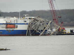
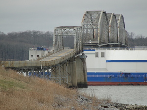
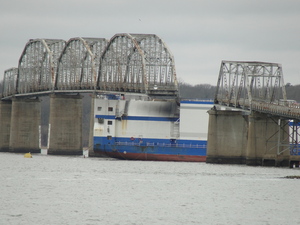
The Eggners Ferry Bridge, which carries U.S. 68/KY 80 across Kentucky Lake, has been closed since it was struck by a cargo ship, the Delta Mariner, on the night of Jan. 26. A 322-foot-long span of the 80-year-old bridge was torn away.
![[US 68] [KY 80]](../images/shields/68-80shield.gif)
Photos Added of Partially Collapsed Eggner Ferry Bridge
On February 4, 2012, officials allowed public access to the eastern approach to the Eggner's Ferry Bridge to view the collapsed span. The bridge carried US 68 and KY 80 over Kentucky Lake (the Tennessee River) between Marshall and Trigg counties. A mainspan of the bridge collapsed after being struck by the cargo vessel MV Delta Mariner on January 26, 2012.
More images: US 68 / KY 80 - Eggner's Ferry Bridge
![[US 68] [KY 80]](../images/shields/68-80shield.gif)
US 68/KY 80 Kentucky Lake/Tennessee River Bridge Partially Collapses
The Associated Press is reporting that the Eggner Ferry Bridge which carries US 68 and KY 80 over Kentucky Lake has partially collapsed after being struck by river traffic. It appears that one of the four main truss sections of the bridge has completely collapsed. There were no injuries reported.
More information: Associated Press: Officials: Portion of SW Ky. bridge collapses (Jan. 26, 2012) ![]() , WAVE3: U.S. 68/KY 80 bridge over Kentucky Lake partially collapses (Jan. 26, 2012)
, WAVE3: U.S. 68/KY 80 bridge over Kentucky Lake partially collapses (Jan. 26, 2012) ![]()
![[US 68] [KY 80]](../images/shields/68-80shield.gif)
Plan for Widening US 68/KY 80 through Land Between the Lakes Presented
The Kentucky Transportation Cabinet recently presented proposed plans for widening US 68/KY 80 through the Land Between the Lakes: WPSD-TV NewsChannel 6: Kentucky: US 68 Expansion- From 2 Lanes To 4 (Dec. 5, 2005) ![]()
![[US 68] [KY 80]](../images/shields/68-80shield.gif)
Land between the Lakes Project Public Meeting Will be Held this Spring
A meeting to discuss the proposed widening of US 68/KY 80 through the Land Between the Lakes will be held sometime this spring: (Hopkinsville) Kentucky New Era: Road projects through LBL subject of hearing (Jan. 7, 2005) ![]()
![[The Trace]](../images/shields/traceshield.gif)
New Land Between the Lakes Plan Envisions Little Change
The U.S. Forest Service’s proposed management plan for the Land Between the Lakes proposes little change over the next 10 to 15 years: Evansville Courier-Press: Plan for managing LBL doesn't see much change (Dec. 13, 2004) ![]()
![[US 62]](../images/shields/us62shield.gif)
Completion of New Kentucky Dam Lock Years Away
The completion of a new lock at Kentucky Dam is not expected until 2010 or 2011. Part of the project includes the relocation of US 62/US 641 and the Paducah & Louisville Railroad to new bridges downstream from the dam. Those bridges are currently under construction: (Hopkinsville) Kentucky New Era: TVA board applauds city, county growth (Oct. 28, 2004) ![]()
![[KY 80]](../images/shields/ky80shield.gif)
Reconstruction of Kentucky 80 between Cadiz and Mayfield Progresses
Funding to continue the reconstruction of KY 80 is included in the new Six-Year Highway Plan. The project to widen KY 80 between Cadiz and Mayfield is broken up into three phases.
- Phase 1 - Aurora to Murray - Construction on this phase of the project is nearly complete. It begins at the approach to US 68-KY 80 bridge over Kentucky Lake and continues westward to US 641 a few miles north of Murray. Construction started several years ago and should be complete this summer.
- Phase 2 - Murray to Mayfield - Construction on this phase was recently begun. This $60 million will construct a new four lane highway between US 641 north of Murray to Mayfield. Construction is expected to last for a couple of years.
- Phase 3 - Cadiz to Aurora - The Six-Year Plan includes $132 million to construct new four lane bridges over Kentucky Lake and Lake Berkeley. Construction on the bridges is scheduled to begin in 2006. Work on the widening project through the Land Between the Lakes has been delayed: the Tennessee Valley Authority gave initial approval for the project; however, ownership of the Land Between the Lakes has since been transferred to the United State Department of Agriculture forest service. Plans for the widening project are expected to be complete this summer, and construction is scheduled for completion in 2007.
The existing two-lane stretch of KY 80 between Aurora and Kentucky 58 east of Mayfield has already been renumbered as KY 402.
More information: Murray Ledger & Times: Committment [sic] shown for Ky. 80 project (Feb. 20, 2004) ![]()
![[US 62]](../images/shields/us62shield.gif)
New Bridge at Kentucky Dam to Open In 2006
The US Army Corps of Engineers is in the process of building a new rail and highway bridge over the Tennessee River just below Kentucky Dam. The bridge is part of a project to build a large navigation lock at Kentucky Dam. The total cost of the project is expected to be $650,000,000. The 1200-foot bridge is expected to open in 2006; lock construction should be completed in 2012.
The bridge will carry US 62 and US 641. Both routes currently cross the river via a road on top of the dam.
More information: WPSD NewsChannel 6: New bridge opens '06 (Nov. 6, 2003) ![]()
![[The Trace]](../images/shields/traceshield.gif)
Site Feature: The Roads of the Land Between the Lakes
I have added a new image gallery consisting of photographs I took of the roads of the Land Between the Lakes. Subjects covered include the US 68/KY 80 bridges over the two lakes, the KY 453 bridge over the Between the Rivers Canal, and road over Kentucky Lake.
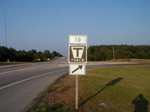 The exit from US 68/KY 80 to The Trace. |
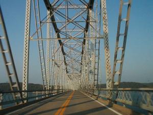 Crossing the US 68/KY 80 bridge over Kentucky Lake. |
| [View All 25 Images] |
![[US 68] [KY 80]](../images/shields/68-80shield.gif)
More Information on US 68/KY 80 Widening through the Land Between the Lakes
Here ![]() is some information from the Kentucky Transportation Cabinet describing the historic and environmental concerns they took into consideration while designing a new route for US 68/KY 80 through the Land Between the Lakes
is some information from the Kentucky Transportation Cabinet describing the historic and environmental concerns they took into consideration while designing a new route for US 68/KY 80 through the Land Between the Lakes ![]() .
.
![[US 68] [KY 80]](../images/shields/68-80shield.gif)
US 68/KY 80 Widening Through the Land Between the Lakes
A planned project to widen US 68/KY 80 to four lanes through the Land Between Lakes National Recreation Area ![]() is expected to cause a great deal of controversy. The $250 million project will replace the two 70-year old bridges of Lake Barkley and Kentucky Lake and construct a four lane highway on a 1000-foot right of way through LBL. The project is planned to begin in 2004, pending approval by the U.S. Forestry Service.
is expected to cause a great deal of controversy. The $250 million project will replace the two 70-year old bridges of Lake Barkley and Kentucky Lake and construct a four lane highway on a 1000-foot right of way through LBL. The project is planned to begin in 2004, pending approval by the U.S. Forestry Service.
Proponents believe the new route would be safer than the current two lane road and increase tourism and commerce in the area; however, critics are concerned about environmental damage.
More information: Kentucky New Era: LBL Road Projects Will Spur Serious Arguments (July 9, 2002) ![]() , Courier-Journal: Divide is forming over proposal for 4-lane road in W. Kentucky (July 8, 2002)
, Courier-Journal: Divide is forming over proposal for 4-lane road in W. Kentucky (July 8, 2002) ![]() (includes photograph of the Kentucky Lake bridge)
(includes photograph of the Kentucky Lake bridge)

